home

[ Content | Sidebar ]

Polhemsplatsen in Göteborg 🇸🇪

May 14th, 2021

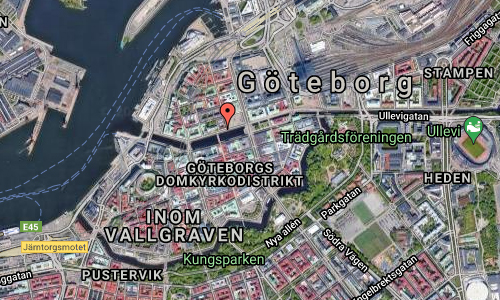
Volvo Photo Locations Part 369
Volvo Photo Locations Overview
bookmark www.volvophotolocations.com today!

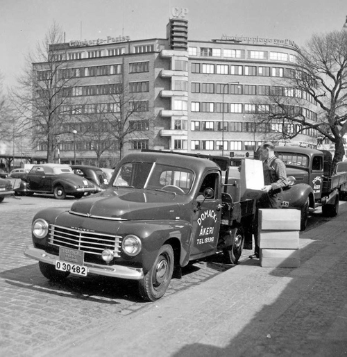
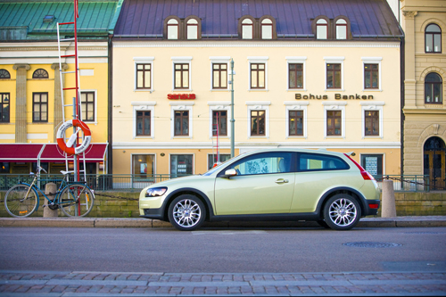
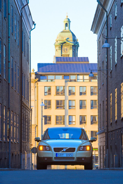
1950 – Volvo P445A Floda from Domacks Åkeri at Polhemsplatsen in Göteborg, Sweden 🇸🇪.

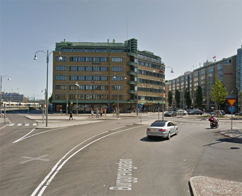
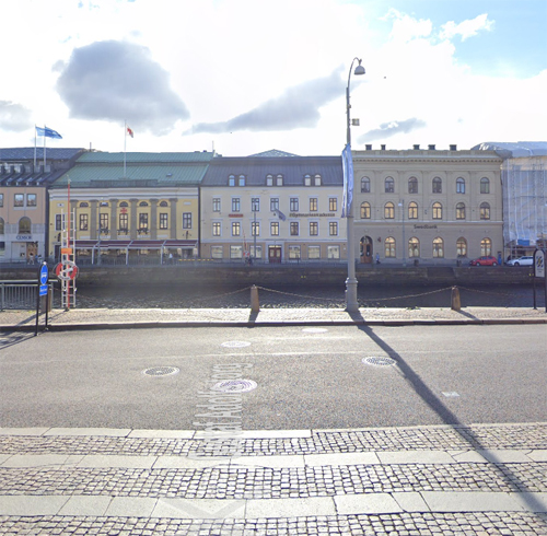
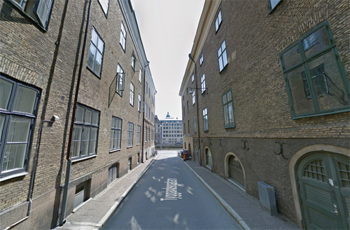
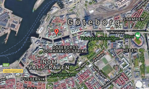
2021 – Polhemsplatsen in Göteborg (Google Streetview)

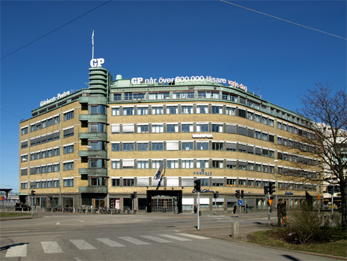
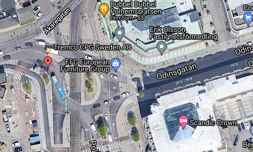
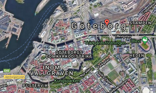
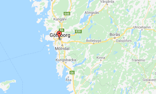
Polhemsplatsen is a traffic junction in the Stampen district in central Göteborg. Polhemsplatsen is located between Stampgatan in the south, Odinsgatan in the east, Burggrevegatan in the north and Åkareplatsen in the west. At Polhemsplatsen you will find the Göteborgs-Posten’s central editorial office and Scandic Crown Hotel.

Polhemsplatsen was named in 1883 after Christoffer Polhem. Christopher Polhammar (18 December 1661 – 30 August 1751) better known as Christopher Polhem, which he took after his ennoblement in 1716, was a Swedish scientist, inventor and industrialist. He made significant contributions to the economic and industrial development of Sweden, particularly mining. He was ennobled by King Charles XII of Sweden for his contributions to Swedish technological development.

His greatest achievement was an automated factory powered entirely by water; automation was very unusual at the time. Built in 1699 in Stjärnsund, the factory produced a number of products including manufacture of knives, locks and clocks. Development of the factory was derived from the idea that Sweden should export fewer raw materials and instead process them within their own borders. The factory met great resistance among workers who feared they would be replaced by machinery. Eventually most of the factory was destroyed in a fire in 1734, leaving only the part of the factory that produced clocks. The factory continued producing clocks, known for their high quality and low price. Although the popularity of the clocks diminished during the beginning of the 19th century, clock-making continues to this day at Stjärnsund, still producing around twenty clocks of the Polhem design per year.

Another product from the factory was the “Polhem locks” (Swedish: Polhemslås), essentially the first design of the variation of padlocks common today. Economically, the factory was unfeasible, but the king at the time, Charles XII, was supportive and gave Polhem freedom from taxes to encourage his efforts. The factory of Stjärnsund was visited by one of his contemporaries, Carl Linnaeus, who wrote about the factory in his diaries as “Nothing is more optimistic than Stjärnsund” (Swedish: Intet är spekulativare än Stjärnsund).

Polhem also contributed to the construction of Göta Canal, a canal connecting the east and west coasts of Sweden. Together with Charles XII of Sweden, he planned the construction of parts of the canal, particularly the canal locks in the 18th century; it was not to be finished until 1832, long after his death.

More information at sv.wikipedia.org and en.wikipedia.org/wiki/Christopher_Polhem.

Volvo Photo Locations

Götaleden in Göteborg 🇸🇪

May 14th, 2021

Volvo Photo Locations Part 368
Volvo Photo Locations Overview
bookmark www.volvophotolocations.com today!

2016 – Volvo S90 R-design on Götaleden (E45) towards Götatunneln in Göteborg, Sweden 🇸🇪.

2021 – Götaleden with entrance to Götatunnel in Göteborg (Google Streetview)

2021 – Götaleden with entrance to Götatunnel in Göteborg (Google Streetview)

Götaleden is the name of a stretch of the E45 through central Göteborg which also includes the Göta tunnel. Götaleden is 3 kilometers long, of which the tunnel is 1.5 kilometers.

Götaleden was originally the name of a projected city motorway for the then E 3 in Göteborg, which was planned in connection with the General Plan for Göteborg City 1964-68 and was then called Stamleden. The trunk route would then feed on the planned Ringleden.

The main traffic route network consists of trunk routes along the river, trails above or below the river, radial trails – mainly national and county roads and ring trails. Until the opening of the Tingstad tunnel in 1968, these were: Norra Stamleden, which started from Torslanda airfield and followed Torslandavägen, Bräckevägen, Stålhandskegatan, Neptunusgatan and the then already extended part of the E 6 north (Norgevägen). Södra Stamleden started in Älvsborg with Torgny Segerstedtsgatan, continued in Oscarsgatan and Masthamnsgatan until the area of Järntorget, where it was divided into two branches that ran along the city area. The northern branch followed Skeppsbron, Sankt Eriksgatan and Mårten Krakowgatan extended to Gamlestadstorg and continued east on Artillerigatan to Kviberg. The southern branch first turned south, then went east through Haga, along Vasa – or Engelbrektsgatan to the area of Mölndalsån, where it turned north to at Viaduktplatsen merge into Riddaregatan and Partillevägen (current E 20). The roads above and below the river united the two tribal roads.

The road would start from Gullbergsmotet at E6 and the Tingstad tunnel. From there, it would consist of Mårten Krakowgatan west past Lilla Bommen, along Packhuskajen and Skeppsbron to Järntorget, where it would meet Oscarsleden.

The first stage was built in 1971-1973. It was only a few hundred meters long and went from Lilla Bommen on a viaduct over the railway track Södra hamnbanan west to Packhusplatsen. The section occupied part of Sankt Eriksgatan and meant that the tramway (then line 2) had to be moved to Östra Hamngatan. In addition, the old Länscellfängelset prison at Lilla Bommen was demolished.

The Gotaleden is also the name of an 71 kilometre walking trail between Göteborg and Alingsås in West Sweden. Beautiful nature, pitstops near to town and proximity to train stations characterise this trail.

The Gotaleden is a walking trail close to the city, which has been divided into nine stages covering a total of 71 kilometres. Proximity to train stations on the different stages makes it easy to adapt the walk as you want. Natural landscapes along the trail are varied and beautiful, with lakes you can swim in, fantastic viewpoints and undulating countryside.
The trail starts (or finishes) in Kungsportsplatsen right in the centre of Gothenburg. From here the trail leads out of the city, along leafy tree lined avenues. Before long you come to Delsjön’s nature reserve, where the many exercise tracks are well used by families and sports clubs. It doesn’t take long however before the hubbub fades away, and the peace and quiet of the countryside takes over.

More information at sv.wikipedia.org and www.vastsverige.com.

Volvo Photo Locations

Norra Hamngatan in Göteborg 🇸🇪

May 14th, 2021

Volvo Photo Locations Part 367
Volvo Photo Locations Overview
bookmark www.volvophotolocations.com today!

2006 – Volvo C30 at Norra Hamngatan in Göteborg 🇸🇪.

2021 – Norra Hamngatan in Göteborg (Google Streetview)

Norra Hamngatan is a street within the Nordstaden district in Göteborg. It is about 700 meters long and extends from Packhusplatsen to Nils Ericsonsgatan.

The street got its name in 1846, after its location north of Stora Hamnkanalen, formerly Stora Hamnen (from the city’s founding in 1621 until the middle of the 18th century). But as early as 1671, the name changed often; Store Hambnens Gatha, Storhamnegatan (1676), Norra store Hamne-gatan (1765) are some of the early names.

The buildings pictured in the Volvo photo are on Södra Hamngatan.

Bohusbanken was one of Sweden’s smallest commercial banks. It was founded in 1919 and sold in 1993 to the insurance company WASA, which changed its name to WASA Banken. WASA in turn merged into Länsförsäkringar a few years later and in 1998 Länsförsäkringar WASA Bank was formed. Bohusbanken was mainly aimed at wealthy private individuals and medium-sized companies.

2009 – Bohus Banken on Södra Hamngatan in Göteborg (Google Streetview)

2011 – Danske Bank on Södra Hamngatan in Göteborg (Google Streetview)

In 1998, Danske Bank in Sweden began using the name Bohusbanken as a trademark for its branches in the Göteborg area. In 2011, the use of the name Bohusbanken was discontinued, as all Swedish branches were renamed Danske Bank.

More information at sv.wikipedia.org.

Volvo Photo Locations

Tyggårdsgatan in Göteborg 🇸🇪

May 14th, 2021

Volvo Photo Locations Part 366
Volvo Photo Locations Overview
bookmark www.volvophotolocations.com today!

2006 – Volvo C30 at Tyggårdsgatan in Göteborg 🇸🇪.

2006 – Volvo C30 at Tyggårdsgatan in Göteborg 🇸🇪.

2021 – Tyggårdsgatan in Göteborg (Google Streetview)

Tyggårdsgatan is a street within the Nordstaden district in Göteborg. It is about 120 meters long and extends from Postgatan to Norra Hamngatan.

The street was named in 1796 after “Tyggården” (today known as Kronhuset) which was built at the beginning of the street between 1643-1654. An earlier name for the street was Nygatan (1739), which was given after the fire on May 10, 1669.

Nordstaden is a district in central Göteborg north of the Stora Hamnkanalen and part of Göteborgs original urban area. The area is divided by Östra Hamngatan, formerly Östra hamnkanalen, in Östra Nordstaden and Västra Nordstaden.

More information at sv.wikipedia.org.

Volvo Photo Locations

Residencia Sagrado Corazón de Jesús on Calle del Tutor in Madrid – ES 🇪🇸

April 5th, 2021

International Volvo Photo Locations Part 466
Historic Volvo Photography Locations Overview
bookmark www.volvophotolocations.com today!

2018 – Volvo XC40 R-Design at Residencia Sagrado Corazón de Jesús on Calle del Tutor in Madrid Spain 🇪🇸.

2018 – Volvo XC40 R-Design at Residencia Sagrado Corazón de Jesús on Calle del Tutor in Madrid Spain 🇪🇸.

2018 – Volvo XC40 R-Design at Residencia Sagrado Corazón de Jesús on Calle del Tutor in Madrid Spain 🇪🇸.

2018 – Volvo XC40 R-Design at Residencia Sagrado Corazón de Jesús on Calle del Tutor in Madrid Spain 🇪🇸.

2018 – Volvo XC40 R-Design at Residencia Sagrado Corazón de Jesús on Calle del Tutor in Madrid Spain 🇪🇸.

2018 – Volvo XC40 R-Design at Residencia Sagrado Corazón de Jesús on Calle del Tutor in Madrid Spain 🇪🇸.

2021 – Residencia Sagrado Corazón de Jesús on Calle del Tutor in Madrid (Google Streetview)

2021 – Residencia Sagrado Corazón de Jesús on Calle del Tutor in Madrid (Google Streetview)

Residencia Sagrado Corazón de Jesús is located on Calle del Tutor and Calle del Buen Suceso in Madrid, Spain.

Built between 1880 and 1882 by the architect Francisco Urquiza y Castillo, it is an interesting building made of brick, on a stone plinth, and in a neo-Mudejar style.
At first it was to be used as a residential building, but finally it was dedicated to a school and a community of religious of the Little Sisters of the Sacred Heart of Jesus.

Calle del Tutor was one of the first ten streets in the Argüelles neighborhood, the result of the urbanization in the mid-nineteenth century of the area known as Montaña del Príncipe Pío, which had the purpose of undertaking the expansion of the city by building an elegant residential neighborhood. Its name, like that of the neighborhood, refers to Agustín Argüelles, tutor of Queen Elizabeth II.

Located in the Moncloa-Aravaca district, its route runs between Ventura Rodríguez Street and Romero Robledo Street; numbering odd ranging from 1 to 65, while pairs 2 to 70. On the way different buildings are featured as the old asylum of the Good Success, residence of the Trinitarian Sisters, the Argüelles Market, the Meliá Madrid hotel or the Palace of the Infanta Isabel de Borbón. The street is also home to the Alberti bookstore.

More information at residenciauniversitariasagradocorazon.es and es.wikipedia.org.

Volvo Photo Locations

MEEU on Calle Agustín de Foxá in Madrid – ES 🇪🇸

April 5th, 2021

International Volvo Photo Locations Part 465
Historic Volvo Photography Locations Overview
bookmark www.volvophotolocations.com today!

2018 – Volvo XC40 at MEEU, Madrid Exposiciones y Eventos Urbanos at La Estación de Chamartín in Madrid Spain 🇪🇸.

2021 – MEEU on Calle Agustín de Foxá in Madrid (Google Streetview)

2018 – Volvo XC60 at MEEU Madrid Exposiciones y Eventos Urbanos at La Estación de Chamartín in Madrid Spain 🇪🇸.

2021 – MEEU on Calle Agustín de Foxá in Madrid (Google Streetview)

MEEU or Madrid Exposiciones y Eventos Urbanos is located on La Estación de Chamartín in Madrid, Spain.

Located in the heart of the city’s financial district, Madrid Exposiciones y Eventos Urbanos is an experiential project located on the upper floor of Chamartín Station, where business and entertainment come together to create a cultural benchmark in Madrid.

With an area of 33,000 square metres, MEEU can host all sorts of public and private events. Companies can organise showrooms, seminars, fairs, markets and congresses in its facilities. It boasts multiple spaces and services for this purpose, including exhibition halls, a business centre, an auditorium, social club, multipurpose pavilions, a skating rink, gym, cinemas and restaurants.

More information at esmadrid.com and meeu.es.

Volvo Photo Locations

Puente Euskalduna in Bilbao – ES 🇪🇸

April 5th, 2021

International Volvo Photo Locations Part 464
Historic Volvo Photography Locations Overview
bookmark www.volvophotolocations.com today!

2012 - Volvo V40 Black Edition R-Design

2012 – Volvo V40 Black Edition R-Design on the Puente Euskalduna (Euskalduna bridge) in Bilbao in Spain 🇪🇸.

2012 - Volvo V40 R-Design

2012 – Volvo V40 R-Design on the Puente Euskalduna (Euskalduna bridge) in Bilbao in Spain 🇪🇸.

2012 – Volvo V40 R-Design on the Puente Euskalduna (Euskalduna bridge) in Bilbao in Spain 🇪🇸.

2021 – Puente Euskalduna in Bilbao

2021 – Puente Euskalduna in Bilbao (Google Streetview)

The Puente Euskalduna or Euskalduna bridge is a bridge over the Bilbao river, in Vizcaya, Basque Country (Spain).

It was opened on April 18, 1997 and its architect was the engineer Javier Manterola. This viaduct, located between the Plaza del Sagrado Corazón de Jesús and Botica Vieja, over the old Euskalduna Shipyards, absorbs much of the traffic from the Deusto bridge. Unique work, designed to provide direct access to motorists from the Asúa Valley with the A-8 motorway, heading to San Sebastián, Vitoria and Santander. A 45 meter high lighting tower gives the project its emblematic element.

Next to one end of the bridge, near the Casilda Iturrizar park, is the Palacio de Congresos y de la Música, known as the Euskalduna Palace, a name taken from the Shipyards located in that same place, closed at the end of the 80s, from where the bridge also takes its name.

The construction of this bridge prevents access to boats that are higher than the eye of the same, which has closed the upper part of the Bilbao estuary to large boats and made the opening of the Deusto drawbridges meaningless. and the City Council.

More information at es.wikipedia.org and bilbaoturismo.net.

Volvo Photo Locations

Brocket Hall in Welwyn, Hertfordshire – UK 🇬🇧

April 5th, 2021

International Volvo Photo Locations Part 463
Historic Volvo Photography Locations Overview
bookmark www.volvophotolocations.com today!

1982 – Volvo 760 GLE at Melbourne Lodge near Brocket Hall in Welwyn, Hertfordshire in Great Britain 🇬🇧.

1982 – Volvo 760 GLE at Melbourne Lodge near Brocket Hall in Welwyn Hertfordshire in UK 🇬🇧.

1982 – Volvo 760 GLE at Melbourne Lodge near Brocket Hall in Welwyn Hertfordshire in UK 🇬🇧.

2021 – Melbourne Lodge near Brocket Hall in Welwyn

2021 – Melbourne Lodge near Brocket Hall in Welwyn

Melbourne Lodge is located near Brocket Hall in Welwyn, Hertfordshire in UK.

Brocket Hall is a classical country house set in a large park at the western side of the urban area of Welwyn Garden City in Hertfordshire, England. The estate is equipped with two golf courses and seven smaller listed buildings, apart from the main house. The freehold on the estate is held by The 3rd Baron Brocket. The house is Grade I-listed.

The estate almost touches the A1(M) motorway near Welwyn Garden City which is on the opposite side of the motorway; administratively and historically it lies at the extreme northern end of Hatfield.

Brocket Hall has been used as filming location for a number of large-scale film and television productions, including Night of the Demon (1957), Murder with Mirrors, Johnny English Reborn, The Queen, Willow and Pride and Prejudice featuring Colin Firth. It also features as the home of character Paul Eirl in the Inspector Morse episode, “Who Killed Harry Field?” (1991) and can be seen in the Agatha Christie’s Poirot episode “The Labours of Hercules” (2013). Brocket Hall was also in Holby City for a wedding. The same venue was used in the Shakin’ Stevens Video of “You Drive Me Crazy” in 1980. The British pop group Steps used it as the location for their 2001 music video for “It’s The Way You Make Me Feel”. Queen Victoria is seen visiting Lord Melbourne at Brocket Hall in several scenes of the ITV drama Victoria.

More information at en.wikipedia.org and brocket-hall.co.uk.

Volvo Photo Locations

Crummock Water in Cockermouth, Lake District National Park – UK 🇬🇧

April 5th, 2021

International Volvo Photo Locations Part 462
Historic Volvo Photography Locations Overview
bookmark www.volvophotolocations.com today!

1980 – Volvo 244 GLE on B5289 alongside Crummock Water in Cockermouth from Buttermere in Lake District National Park, United Kingdom 🇬🇧.

1980 – Volvo 244 GLE on B5289 alongside Crummock Water in Cockermouth from Buttermere in Lake District National Park, United Kingdom 🇬🇧.

1979 – Volvo 244 GLE on B5289 alongside Crummock Water in Cockermouth from Buttermere in Lake District National Park, United Kingdom 🇬🇧.

1980 – Volvo 244 GL on B5289 alongside Crummock Water in Cockermouth from Buttermere in Lake District National Park, United Kingdom 🇬🇧.

B5289 is a road alongside Crummock Water in Cockermouth from Buttermere in Lake District National Park

Crummock Water is a lake in the Lake District in Cumbria, North West England situated between Buttermere to the south and Loweswater to the north. Crummock Water is 4.0 km long, 0.97 km wide and 43 m deep. The River Cocker is considered to start at the north of the lake, before then flowing into Lorton Vale. The hill of Mellbreak runs the full length of the lake on its western side; as Alfred Wainwright described it ‘no pairing of hill and lake in Lakeland have a closer partnership than these’.

“The meaning of ‘Crummock’ seems to be ‘Crooked one’, from British” (Brythonic Celtic) “‘crumbaco’-‘crooked'”. This may refer to the winding course of the River Cocker, which flows out of the lake, or refer to the bending nature of the lake itself. The word “‘water’ is the main Lakeland term for ‘lake'”.

The lake is owned by the National Trust. Scale Force, the highest waterfall in the Lake District, feeds the lake and has a drop of 52 m.

Water from the lake is treated at Cornhow water treatment works, near Loweswater, and is distributed to the towns of Silloth-on-Solway, Maryport, Workington, Whitehaven, and many smaller towns, villages, and hamlets in the surrounding area for drinking and all other uses.

More information at en.wikipedia.org and visitlakedistrict.com.

Volvo Photo Locations

Kirkstone Pass in Ullswater Valle in the Lake District National Park – UK 🇬🇧

April 5th, 2021

International Volvo Photo Locations Part 461
Historic Volvo Photography Locations Overview
bookmark www.volvophotolocations.com today!

1980 - Volvo 264 GLE somewhere in England or Scotland?

1980 – Volvo 264 GLE on Kirkstone Pass on the A592 road between Ambleside in Rothay Valley and Patterdale in Ullswater Valle in the Lake District National Park, United Kingdom 🇬🇧.

1980 – Volvo 264 GLE on Kirkstone Pass on the A592 road between Ambleside in Rothay Valley and Patterdale in Ullswater Valle in the Lake District National Park, United Kingdom 🇬🇧.

1980 – Volvo 264 GLE on Kirkstone Pass on the A592 road between Ambleside in Rothay Valley and Patterdale in Ullswater Valle in the Lake District National Park, United Kingdom 🇬🇧.

2021 – Kirkstone Pass (Google Streetview)

1980 – Volvo 244 GLE on Kirkstone Pass on the A592 road between Ambleside in Rothay Valley and Patterdale in Ullswater Valle in the Lake District National Park, United Kingdom 🇬🇧.

1980 – Volvo 244 GLE on Kirkstone Pass on the A592 road between Ambleside in Rothay Valley and Patterdale in Ullswater Valle in the Lake District National Park, United Kingdom 🇬🇧.

1980 – Volvo 244 GL D6 on Kirkstone Pass on the A592 road between Ambleside in Rothay Valley and Patterdale in Ullswater Valle in the Lake District National Park, United Kingdom 🇬🇧.

1980 – Volvo 244 GL D6 on Kirkstone Pass on the A592 road between Ambleside in Rothay Valley and Patterdale in Ullswater Valle in the Lake District National Park, United Kingdom 🇬🇧.

2021 – Kirkstone Pass (Google Streetview)

Kirkstone Pass is a mountain pass in the English Lake District, in the county of Cumbria. It is at an altitude of 454 metres.

It is the District’s highest pass traversed by road, the A592 road between Ambleside in Rothay Valley and Patterdale in Ullswater Valley. The road gradient approaches 1 in 4. The picturesque view down into Patterdale has Brothers Water as its focal point.

The Kirkstone Pass Inn stands close to the summit. Once a vital coaching inn, it now caters primarily for tourists. It is the third-highest public house in England.

The name of the pass comes from a prominent stone, the Kirkstone, which stands a few yards from the A592 on the Patterdale side of the inn. Its shadow resembles a steeple; ‘kirk’ means church in old Norse and was a variant in related Old English.

In local names the climb from Ambleside is known as The Struggle.

More information at en.wikipedia.org and visitcumbria.com.

Volvo Photo Locations